1954 Map of Tulsa
USGS Topo · Published 1954About this map
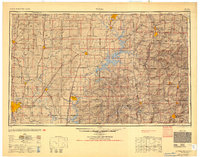
The Ozark Plateau and Boston Mountains define the rugged topography of this mid-century survey, covering the intersection of Oklahoma, Missouri, and Arkansas. Significant industrial and military footprints appear across the landscape, notably the Oklahoma Ordnance Works near Pryor and the sprawling Camp Crowder military reservation to the east. The region's water management is in a state of development, featuring the expansive Grand Lake O' the Cherokees and the Oologah Res along the Verdigris River.
Find a feature on this map
45 named features on this map. Tap any name to fly to it.
Don’t see what you’re looking for? This feature index may not catch every label — zoom into the map to look around manually.
Map Details
Editions of this 1954 Tulsa Map
2 editions found

Other maps of this area

1885 · Sedan
USGS Topo · 1:125,000

1886 · Joplin
USGS Topo · 1:125,000

1886 · Greenfield
USGS Topo · 1:125,000

1886 · Independence
USGS Topo · 1:125,000

1886 · Carthage
USGS Topo · 1:125,000

1886 · Parsons
USGS Topo · 1:125,000

1888 · Greenfield
USGS Topo · 1:125,000

1889 · Sedan
USGS Topo · 1:125,000

1893 · Parsons
USGS Topo · 1:125,000

1894 · Independence
USGS Topo · 1:125,000