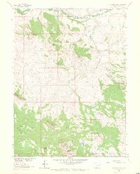
1962 Map of Tumble Mountain
USGS Topo · Published 1971About this map
The Little Snake River carves a path through northern Routt County, defining the drainage of this highland territory mapped in the early 1960s. The landscape is characterized by prominent peaks including West Gibraltar Peak, East Gibraltar Peak, and the namesake Tumble Mountain, while lower-lying areas like Maria Bottoms provided rare flat ground for settlement. Ranching activity is evident at the Focus Ranch near a Gaging Sta on the river and at A Diamond J Ranch to the east. A complex network of Jeep Trails and Trails suggests a rugged interior dependent on seasonal access for livestock or resource management. Water sources like Willow Creek, Beaver Creek, and Gold Blossom Creek feed into the river system, while landmarks such as Gold Blossom Rocks and Circle Ridge provide distinct navigational points in the southern reaches near South Fork Park.
Find a feature on this map
30 named features on this map. Tap any name to fly to it.
Don’t see what you’re looking for? This feature index may not catch every label — zoom into the map to look around manually.
Map Details
Editions of this 1962 Tumble Mountain Map
3 editions found
Other maps of this area

1932 · Savery
USGS Topo · 1:96,000

1940 · Savery
USGS Topo · 1:125,000

1954 · Rawlins
USGS Topo · 1:250,000

1954 · Craig
USGS Topo · 1:250,000

1957 · Craig
USGS Topo · 1:250,000

1958 · Rawlins
USGS Topo · 1:250,000

1958 · Craig
USGS Topo · 1:250,000

1960 · Craig
USGS Topo · 1:250,000

1961 · Grieve Reservoir
USGS Topo · 1:24,000
1961 · Fletcher Peak
USGS Topo · 1:24,000