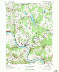
1946 Map of Tunkhannock
USGS Topo · Published 1971About this map
Tunkhannock serves as the focal point of this Pennsylvania landscape, situated at the dramatic bend where Tunkhannock Creek meets the Susquehanna River. The mapping documents the transition of the mid-20th century, showing the established Lehigh Valley railroad line following the riverbank while the Roosevelt Highway cuts through the northern hills. Beyond the village center, the terrain is defined by family-named landmarks like Valentine Hill and Shupp Hill, alongside numerous water bodies such as Lake Carey and Oxbow Lake. Local heritage is preserved through the inclusion of rural gathering places like Marcy Ch and schools including Eatonville Sch and Castle Sch. The presence of Skyhaven Landing Field near the river and the Dixon gauging station highlights the area's mixed transportation and utility infrastructure during this era.
Find a feature on this map
58 named features on this map. Tap any name to fly to it.
Don’t see what you’re looking for? This feature index may not catch every label — zoom into the map to look around manually.
Map Details
Editions of this 1946 Tunkhannock Map
Other maps of this area

1891 · Harveys Lake
USGS Topo · 1:62,500

1893 · Harvey Lake
USGS Topo · 1:62,500

1893 · Pittston
USGS Topo · 1:62,500

1943 · Scranton
USGS Topo · 1:125,000

1945 · Meshoppen
USGS Topo · 1:62,500

1945 · Auburn Center
USGS Topo · 1:24,000

1945 · Meshoppen
USGS Topo · 1:24,000

1946 · Tunkhannock
USGS Topo · 1:62,500

1946 · Noxen
USGS Topo · 1:24,000

1946 · Ransom
USGS Topo · 1:24,000
Featured Places
- Falls Township, PA
- Tunkhannock, PA
- Lemon Township, PA
- Brookside, Tunkhannock Township
- Marcy, Tunkhannock Township