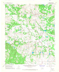
1966 Map of Tupelo
USGS Topo · Published 1968About this map
The town of Tupelo serves as a central hub on this mid-1960s survey, situated at the junction of the Kansas Oklahoma and Gulf and the Atchison Topeka and Santa Fe railroads. The map reveals a landscape defined by significant historic markers, notably the Old Indian Treaty Boundary cutting through the center and the Old RR Grade in the northeast. Waterways such as Clear Boggy Creek, Coal Creek, and Leader Creek meander across the terrain, shaping the development of local agriculture and transit. Genealogists will find several distinct burial sites and community centers, including Byrds Prairie Cem, Wilson Cem, and the Pleasant Hill Ch adjacent to Pleasant Hill Cem. The presence of several Gravel Pits and the wooded rises of the Jack Hills point to the local extractive industries and the natural topography of Coal County during this era.
Find a feature on this map
22 named features on this map. Tap any name to fly to it.
Don’t see what you’re looking for? This feature index may not catch every label — zoom into the map to look around manually.
Map Details
Editions of this 1966 Tupelo Map
3 editions found
Other maps of this area

1896 · Coalgate
USGS Topo · 1:125,000

1899 · Coalgate
USGS Topo · 1:125,000

1899 · Atoka
USGS Topo · 1:125,000

1900 · Atoka
USGS Topo · 1:125,000

1900 · Coalgate
USGS Topo · 1:125,000

1901 · Stonewall
USGS Topo · 1:125,000

1901 · Tishomingo
USGS Topo · 1:125,000

1957 · Stonewall
USGS Topo · 1:24,000

1957 · Centrahoma
USGS Topo · 1:24,000

1957 · Tupelo NE
USGS Topo · 1:24,000