
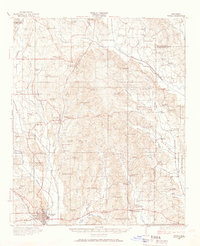
1921 Map of Tupelo
USGS Topo · Published 1921About this map
Tupelo serves as the primary hub for this early 1920s survey of Lee County, where the intersection of the Mobile and Ohio Railroad and the St Louis and San Francisco Road establishes a vital regional transit corridor. The map reveals a dense network of rural community centers, particularly noteworthy for its high concentration of local schools like Brysons School and Mud Creek School, and churches such as Euclautubba Church. These features suggest a landscape of small-scale agriculture organized around localized social hubs.
Find a feature on this map
60 named features on this map. Tap any name to fly to it.
Don’t see what you’re looking for? This feature index may not catch every label — zoom into the map to look around manually.
Map Details
Editions of this 1921 Tupelo Map
2 editions found
Other maps of this area

1921 · Booneville
USGS Topo · 1:48,000

1922 · Booneville
USGS Topo · 1:62,500

1923 · Tupelo
USGS Topo · 1:62,500

1955 · Ripley
USGS Topo · 1:62,500

1955 · Sherman
USGS Topo · 1:62,500

1956 · Tupelo
USGS Topo · 1:250,000

1958 · Tupelo
USGS Topo · 1:250,000

1965 · Mooreville
USGS Topo · 1:24,000

1965 · Fulton
USGS Topo · 1:24,000
1965 · Marietta
USGS Topo · 1:24,000