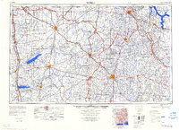
1984 Map of Tupelo
USGS Topo · Published 1984About this map
Tupelo and Oxford anchor this detailed study of North Mississippi, highlighting a landscape defined by large-scale water management projects and significant academic institutions. The map illustrates the massive reservoirs of Sardis Lake, Enid Lake, and Arkabutla Lake along the western edge, created by dams like the Sardis Dam and Enid Dam to control the tributaries of the Yazoo River basin. To the east, the terrain rises toward Woodall Mountain, the highest point in the state, while the historic Natchez Trace Parkway cuts diagonally across the center, tracing an ancient path through Pontotoc and Tupelo.
Find a feature on this map
140 named features on this map. Tap any name to fly to it.
Don’t see what you’re looking for? This feature index may not catch every label — zoom into the map to look around manually.
Map Details
Editions of this 1984 Tupelo Map
3 editions found
Other maps of this area

1905 · Waynesboro
USGS Topo · 1:125,000

1911 · Iuka
USGS Topo · 1:48,000

1914 · Iuka
USGS Topo · 1:62,500

1916 · Memphis
USGS Topo · 1:62,500

1921 · Booneville
USGS Topo · 1:48,000

1921 · Tupelo
USGS Topo · 1:48,000

1922 · Booneville
USGS Topo · 1:62,500

1923 · Tupelo
USGS Topo · 1:62,500

1924 · Gravelly Springs
USGS Topo · 1:48,000

1925 · Memphis
USGS Topo · 1:48,000