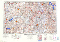
1984 Map of Tupelo
USGS Topo · Published 1984About this map
Tupelo serves as a central hub in this survey of Northeast Mississippi, where the St Louis-San Francisco RR and Illinois Central Gulf RR intersect. The landscape is defined by massive flood control projects and water management systems, including the expansive Sardis Lake, Enid Lake, and Arkabutla Lake to the west, and the Pickwick Lake and Tennessee River system in the northeast. These reservoirs, alongside the Tallahatchie River and Tombigbee River, illustrate the mid-century transformation of the region's hydrology by the Corps of Engineers. Educational and recreational landmarks are prominent, from the University of Mississippi in Oxford to the high point at Woodall Mountain. Large tracts of the Holly Springs National Forest and Tombigbee National Forest anchor the wooded terrain between growing settlements like Corinth, New Albany, and Booneville.
Find a feature on this map
93 named features on this map. Tap any name to fly to it.
Don’t see what you’re looking for? This feature index may not catch every label — zoom into the map to look around manually.
Map Details
Editions of this 1984 Tupelo Map
3 editions found
Other maps of this area

1905 · Waynesboro
USGS Topo · 1:125,000

1911 · Iuka
USGS Topo · 1:48,000

1914 · Iuka
USGS Topo · 1:62,500

1916 · Memphis
USGS Topo · 1:62,500

1921 · Booneville
USGS Topo · 1:48,000

1921 · Tupelo
USGS Topo · 1:48,000

1922 · Booneville
USGS Topo · 1:62,500

1923 · Tupelo
USGS Topo · 1:62,500

1924 · Gravelly Springs
USGS Topo · 1:48,000

1925 · Memphis
USGS Topo · 1:48,000