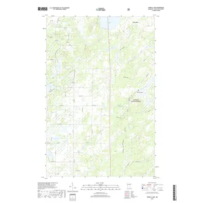
2019 Map of Turpela Lake
USGS Topo · Published 2019About this map
Saint Louis River and the Partridge River dominate this portion of the Iron Range landscape, winding through a dense network of wetlands and small lakes. The community of Hoyt Lakes sits in the northeast, while the smaller settlement at Norway Point and the location of Koivisto represent the rural residential pockets in this heavily wooded area. Much of the eastern terrain is protected within the Superior National Forest, characterized by its numerous logging and industrial rail spurs including the Mooseline and various branches like Mooseline Spur K and Mooseline Spur H. The map reveals a land defined by water and timber, with Turpela Lake, Whitewater Lake, and Kumpala Lake interspersed between township roads. This 2019 survey documents the modern layout of rural St. Louis County, where old rail corridors and forest service roads like Palo Road 41 provide the primary access to the backcountry.
Find a feature on this map
49 named features on this map. Tap any name to fly to it.
Don’t see what you’re looking for? This feature index may not catch every label — zoom into the map to look around manually.
Map Details
Editions of this 2019 Turpela Lake Map
This is the sole edition of this map. No revisions or reprints were ever made.
Other maps of this area

1949 · Aurora
USGS Topo · 1:24,000

1949 · Allen
USGS Topo · 1:24,000

1950 · Allen
USGS Topo · 1:24,000

1950 · Aurora
USGS Topo · 1:24,000

1950 · Biwabik
USGS Topo · 1:24,000

1951 · Biwabik
USGS Topo · 1:24,000

1951 · Palo
USGS Topo · 1:24,000

1951 · Makinen
USGS Topo · 1:24,000

1954 · Hibbing
USGS Topo · 1:250,000

1957 · Hibbing
USGS Topo · 1:250,000