
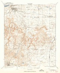
1924 Map of Tuscumbia
USGS Topo · Published 1924About this map
Tuscumbia and Sheffield serve as the northern anchors of this 1924 landscape, situated just south of the Tennessee River and Sevenmile Island. The survey captures the region during a period of transition, where established river towns and rail hubs like Leighton contrast with the rural upland communities of the La Grange Mountains. A dense network of local education and faith is evident, with numerous institutions such as the Morning Star School, Old Bethlehem School, and Glendale Church scattered across the township lines.
Find a feature on this map
77 named features on this map. Tap any name to fly to it.
Don’t see what you’re looking for? This feature index may not catch every label — zoom into the map to look around manually.
Map Details
Editions of this 1924 Tuscumbia Map
2 editions found
Other maps of this area

1914 · Rogersville
USGS Topo · 1:48,000

1914 · Muscle Shoals
USGS Topo · 1:48,000

1916 · Muscle Shoals
USGS Topo · 1:62,500

1916 · Rogersville
USGS Topo · 1:62,500

1924 · Gravelly Springs
USGS Topo · 1:48,000

1925 · Barton
USGS Topo · 1:62,500

1926 · Tuscumbia
USGS Topo · 1:62,500

1926 · Barton
USGS Topo · 1:48,000

1926 · Gravelly Springs
USGS Topo · 1:62,500

1929 · Barton
USGS Topo · 1:62,500