1909 Map of Tuskahoma
USGS Topo · Published 1945About this map
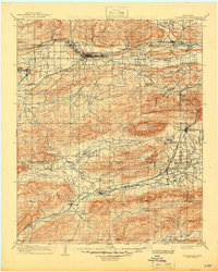
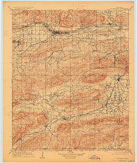
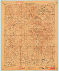
The Choctaw Council House stands as a central landmark in this 1909 snapshot of the Choctaw Nation’s territory, shortly after Oklahoma statehood. The landscape is defined by the heavy infrastructure of the Chicago Rock Island and Pacific and the St Louis and San Francisco railroads, which facilitated the growth of coal-mining hubs like Wilburton and timber settlements such as Talihina. Between the ridges of Buffalo Mountain and the Winding Stair Mountain, a network of small communities including Tuskahoma, Clayton, and Red Oak follow the fertile valleys of the Kiamichi River and Fourche Maline. This survey, based on original work by C.H. Fitch, captures the transition from tribal sovereignty to the industrial rail-and-resource economy of the early twentieth century, noting local religious centers like the Thessalonian Church and Peaceable Chapel.
Find a feature on this map
53 named features on this map. Tap any name to fly to it.
Don’t see what you’re looking for? This feature index may not catch every label — zoom into the map to look around manually.
Map Details
Editions of this 1909 Tuskahoma Map
3 editions found

Other maps of this area

1898 · McAlester
USGS Topo · 1:125,000

1900 · Sansbois
USGS Topo · 1:125,000

1900 · Canadian
USGS Topo · 1:125,000

1900 · Sallisaw
USGS Topo · 1:125,000

1900 · Winding Stair
USGS Topo · 1:125,000

1901 · Antlers
USGS Topo · 1:125,000

1901 · Tuskahoma
USGS Topo · 1:125,000

1901 · Alikchi
USGS Topo · 1:125,000
1902 · Lukfata
USGS Topo · 1:125,000

1908 · Tuskahoma
USGS Topo · 1:125,000