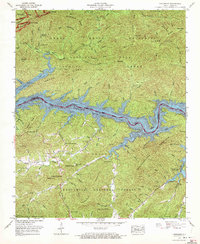
1961 Map of Tuskeegee
USGS Topo · Published 1972About this map
Fontana Lake dominates the central landscape of this 1961 survey, where the Little Tennessee River was impounded to create a massive reservoir at an elevation of 1,708 feet. The map captures the meeting of two major federal lands: the Great Smoky Mountains National Park to the north and the Nantahala National Forest to the south. Along the northern shores, the settlement of Proctor sits at the mouth of Hazel Creek, accompanied by several family burial sites including Proctor Cem and Hall Cem.
Find a feature on this map
81 named features on this map. Tap any name to fly to it.
Don’t see what you’re looking for? This feature index may not catch every label — zoom into the map to look around manually.
Map Details
Editions of this 1961 Tuskeegee Map
4 editions found
Other maps of this area

1886 · Knoxville
USGS Topo · 1:125,000

1892 · Knoxville
USGS Topo · 1:125,000

1894 · Knoxville
USGS Topo · 1:125,000

1895 · Knoxville
USGS Topo · 1:125,000

1901 · Knoxville
USGS Topo · 1:125,000

1933 · Bushnell
USGS Topo · 1:62,500

1935 · Robbinsville
USGS Topo · 1:24,000

1935 · Fontana
USGS Topo · 1:24,000

1936 · Proctor
USGS Topo · 1:24,000

1936 · Wesser
USGS Topo · 1:24,000