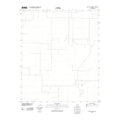
2010 Map of Two B Ranch NW
USGS Topo · Published 2010About this map
Landon Oil Field defines the industrial footprint of this portion of Cochran County, situated in the southern half of the quadrangle. The landscape is characterized by a sparse, grid-like network of rural transit, dominated by a system of county roads and the lateral stretch of Fm 1585 to the north. This 2010 survey shows a terrain shaped by the oil industry and agricultural division, where roads like Co Rd 260 and Co Rd 95 provide the primary access to remote properties. The minimal density of named features suggests an area focused on resource extraction and large-scale ranching, typical of the Llano Estacado region of the Texas Panhandle.
Find a feature on this map
8 named features on this map. Tap any name to fly to it.
Don’t see what you’re looking for? This feature index may not catch every label — zoom into the map to look around manually.
Map Details
Editions of this 2010 Two B Ranch NW Map
This is the sole edition of this map. No revisions or reprints were ever made.
Other maps of this area

1954 · Brownfield
USGS Topo · 1:250,000

1958 · Brownfield
USGS Topo · 1:250,000

1962 · Brownfield
USGS Topo · 1:250,000

1969 · Lehman
USGS Topo · 1:24,000

1970 · Bronco NE
USGS Topo · 1:24,000

1970 · Bronco
USGS Topo · 1:24,000

1970 · Bledsoe
USGS Topo · 1:24,000

1970 · Morton SW
USGS Topo · 1:24,000

1971 · Schooler Ranch
USGS Topo · 1:24,000
1971 · Two B Ranch
USGS Topo · 1:24,000