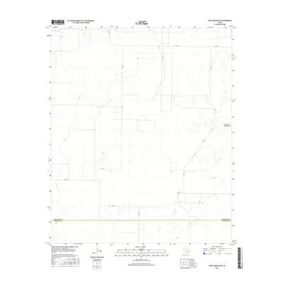
2016 Map of Two B Ranch NW
USGS Topo · Published 2016About this map
The South Fork Sulphur Draw winds through this High Plains landscape, marking one of the few natural hydrographic features in an otherwise grid-defined agricultural region. This area, located along the southern border of Cochran Co and the northern edge of Yoakum Co, shows a transition from structured ranch land to the open draws of the Llano Estacado. The road network, including FM 1585 and various county routes like Co Rd 57 and Co Rd 260, reflects the systematic land partitioning common in West Texas. These secondary roads provide essential access to remote ranching operations and agricultural fields, tracing the legacy of large-scale land management in this part of the state. The terrain is characterized by subtle elevation changes and depressions that collect seasonal water, visible in the contour patterns surrounding the main draw.
Find a feature on this map
9 named features on this map. Tap any name to fly to it.
Don’t see what you’re looking for? This feature index may not catch every label — zoom into the map to look around manually.
Map Details
Editions of this 2016 Two B Ranch NW Map
This is the sole edition of this map. No revisions or reprints were ever made.
Other maps of this area

1954 · Brownfield
USGS Topo · 1:250,000

1958 · Brownfield
USGS Topo · 1:250,000

1962 · Brownfield
USGS Topo · 1:250,000
1969 · Lehman
USGS Topo · 1:24,000
1970 · Bronco NE
USGS Topo · 1:24,000
1970 · Bronco
USGS Topo · 1:24,000
1970 · Bledsoe
USGS Topo · 1:24,000
1970 · Morton SW
USGS Topo · 1:24,000
1971 · Schooler Ranch
USGS Topo · 1:24,000
1971 · Two B Ranch
USGS Topo · 1:24,000