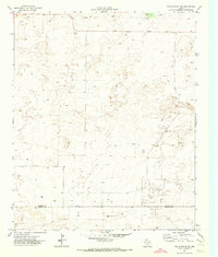
1971 Map of Two B Ranch NW
USGS Topo · Published 1973About this map
The boundary of Cochran Co and Yoakum Co bisects this West Texas landscape, which is defined by its industrial activity in the early 1970s. The southeastern corner is dominated by the Landon Oil Field, a dense network of petroleum infrastructure including numerous Oil Wells and supporting service roads. This resource extraction extends northward, where several clusters of wells are scattered across the high plains. Aside from the energy sector, the map reveals localized land use through a Gravel Pit and various water-management features, including windmills and tanks typical of the region's ranching heritage. The terrain is largely defined by depressions and isolated wells, reflecting a specialized economy where water and oil were the primary drivers of settlement and development.
Find a feature on this map
5 named features on this map. Tap any name to fly to it.
Don’t see what you’re looking for? This feature index may not catch every label — zoom into the map to look around manually.
Map Details
Editions of this 1971 Two B Ranch NW Map
This is the sole edition of this map. No revisions or reprints were ever made.
Other maps of this area

1954 · Brownfield
USGS Topo · 1:250,000

1958 · Brownfield
USGS Topo · 1:250,000

1962 · Brownfield
USGS Topo · 1:250,000

1969 · Lehman
USGS Topo · 1:24,000

1970 · Bronco NE
USGS Topo · 1:24,000

1970 · Bronco
USGS Topo · 1:24,000

1970 · Bledsoe
USGS Topo · 1:24,000

1970 · Morton SW
USGS Topo · 1:24,000

1971 · Schooler Ranch
USGS Topo · 1:24,000
1971 · Two B Ranch
USGS Topo · 1:24,000