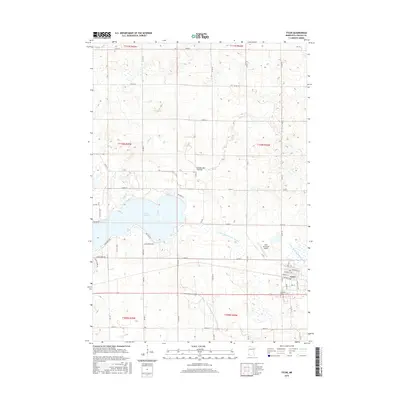
2016 Map of Tyler
USGS Topo · Published 2016About this map
The glacial highlands of the Coteau des Prairies dominate this portion of Lincoln County, defining the drainage patterns that feed into Coon Cr and a series of managed waterways like County Ditch Number Fifteen. Central to the landscape is the eastern reach of Lake Benton, surrounded by a network of seasonal and residential roads such as Shady Shore Dr and Lemon Point Rd. This 2016 survey illustrates the intersection of natural lakeside topography with the rigid grid of agricultural sections and township boundaries.
Find a feature on this map
54 named features on this map. Tap any name to fly to it.
Don’t see what you’re looking for? This feature index may not catch every label — zoom into the map to look around manually.
Map Details
Editions of this 2016 Tyler Map
This is the sole edition of this map. No revisions or reprints were ever made.
Other maps of this area

1953 · Watertown
USGS Topo · 1:250,000

1958 · Watertown
USGS Topo · 1:250,000

1963 · Dead Coon Lake
USGS Topo · 1:24,000

1963 · Gislason Lake
USGS Topo · 1:24,000

1963 · Tyler
USGS Topo · 1:24,000

1963 · Arco
USGS Topo · 1:24,000
1967 · Ruthton
USGS Topo · 1:24,000

1967 · Ruthton NW
USGS Topo · 1:24,000

1967 · Verdi
USGS Topo · 1:24,000

1967 · Lake Benton
USGS Topo · 1:24,000