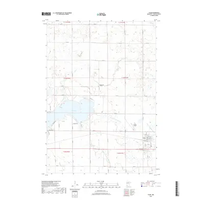
2019 Map of Tyler
USGS Topo · Published 2019About this map
The town of Tyler serves as the focal point of this southwestern Minnesota survey, situated along the prominent upland known as the Coteau des Prairies. This geographical feature, often called the highland of the prairies, dictates the local drainage patterns and creates the rolling landscape that surrounds the settlement. To the west, the significant waters of Lake Benton dominate the terrain, with several developed lakefront roads like N Shore Dr and Edgewater Dr indicating its local importance for recreation and residence.
Find a feature on this map
51 named features on this map. Tap any name to fly to it.
Don’t see what you’re looking for? This feature index may not catch every label — zoom into the map to look around manually.
Map Details
Editions of this 2019 Tyler Map
This is the sole edition of this map. No revisions or reprints were ever made.
Other maps of this area

1953 · Watertown
USGS Topo · 1:250,000

1958 · Watertown
USGS Topo · 1:250,000

1963 · Dead Coon Lake
USGS Topo · 1:24,000

1963 · Gislason Lake
USGS Topo · 1:24,000

1963 · Tyler
USGS Topo · 1:24,000

1963 · Arco
USGS Topo · 1:24,000
1967 · Ruthton
USGS Topo · 1:24,000

1967 · Ruthton NW
USGS Topo · 1:24,000

1967 · Verdi
USGS Topo · 1:24,000

1967 · Lake Benton
USGS Topo · 1:24,000