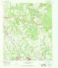
1966 Map of Tyler North
USGS Topo · Published 1969About this map
Tyler State Park and the expanding northern reaches of Tyler define this landscape during a period of significant mid-century growth. The map illustrates a transitional environment where agricultural research at the State Agricultural Experiment Station meets the industrial footprints of the Missouri Pacific and St Louis Southwestern railroads. These rail lines, alongside a network of creeks like Little Saline Creek and Black Fork Creek, shaped the settlement patterns of outlying communities such as Swan and Pine Springs.
Find a feature on this map
55 named features on this map. Tap any name to fly to it.
Don’t see what you’re looking for? This feature index may not catch every label — zoom into the map to look around manually.
Map Details
Editions of this 1966 Tyler North Map
2 editions found
Other maps of this area

1938 · Winona
USGS Topo · 1:48,000

1943 · Winona
USGS Topo · 1:62,500

1948 · Tyler
USGS Topo · 1:62,500

1949 · Tyler
USGS Topo · 1:62,500

1956 · Tyler
USGS Topo · 1:250,000

1960 · Hawkins
USGS Topo · 1:24,000

1960 · Lindale
USGS Topo · 1:24,000

1960 · Crow
USGS Topo · 1:24,000

1966 · Chandler
USGS Topo · 1:24,000
1966 · Mount Sylvan
USGS Topo · 1:24,000