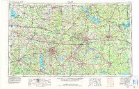
1956 Map of Tyler
USGS Topo · Published 1992About this map
Tyler serves as the focal point for this mid-century portrait of East Texas, a region defined by its dense network of river systems and growing post-war industrial footprint. The landscape is dominated by major water projects including Lake Tawakoni and the Toledo Bend Reservoir, which altered the hydrology of the Sabine River and Neches River basins. Transportation corridors like Interstate 20 and the Texas & Pacific RR illustrate the connectivity between major centers like Longview and Marshall.
Find a feature on this map
91 named features on this map. Tap any name to fly to it.
Don’t see what you’re looking for? This feature index may not catch every label — zoom into the map to look around manually.
Map Details
Editions of this 1956 Tyler Map
5 editions found

Other maps of this area

1907 · Atlanta
USGS Topo · 1:62,500

1910 · Linden
USGS Topo · 1:62,500

1910 · Atlanta
USGS Topo · 1:62,500

1914 · Daingerfield
USGS Topo · 1:62,500

1920 · Kemp
USGS Topo · 1:62,500

1932 · Hosston NW
USGS Topo · 1:31,680

1932 · Hosston SW
USGS Topo · 1:31,680

1935 · Henderson
USGS Topo · 1:48,000

1936 · Kilgore
USGS Topo · 1:48,000

1937 · Troupe
USGS Topo · 1:48,000