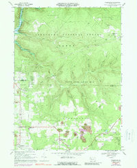
1967 Map of Tylersburg
USGS Topo · Published 1988About this map
The Baltimore and Ohio rail line cuts across this landscape, connecting the small communities of Tylersburg and Crown in northwestern Pennsylvania. This mid-century survey captures a region defined by its overlapping forest and resource management areas, including portions of the Allegheny National Forest, State Game Lands No 24, and Cook Forest State Park. The terrain is characterized by deeply etched drainage systems like Coon Creek and Irish Run, which descend toward the waters of Tionesta Lake in the northwest corner.
Find a feature on this map
33 named features on this map. Tap any name to fly to it.
Don’t see what you’re looking for? This feature index may not catch every label — zoom into the map to look around manually.
Map Details
Editions of this 1967 Tylersburg Map
4 editions found
Other maps of this area

1918 · Loleta
USGS Topo · 1:62,500

1922 · Tionesta
USGS Topo · 1:62,500

1924 · Tionesta
USGS Topo · 1:62,500

1927 · Tidioute
USGS Topo · 1:48,000

1930 · Tidioute
USGS Topo · 1:62,500

1935 · Sheffield
USGS Topo · 1:48,000

1936 · Marienville
USGS Topo · 1:48,000

1941 · Sheffield
USGS Topo · 1:62,500

1941 · Marienville
USGS Topo · 1:62,500

1946 · Tionesta
USGS Topo · 1:62,500
Featured Places
- Kingsley Township, PA
- Lickingville, PA
- Guitonville, Green Township
- Green Township, PA
- Frills Corners, PA