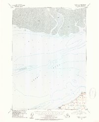
1952 Map of Tyonek A-2
USGS Topo · Published 1954About this map
Cook Inlet dominates this mid-century hydrographic study, revealing the shifting shoals and tidal flats of the upper reach near the Susitna River mouth. The northern coastline is defined by the expansive Susitna Flats and heavy deposits of Mud, which create a complex navigable environment. Along the southern shore, the boundary of the Kenai National Moose Range encompasses the rugged coastline near Point Possession. The mapping shows small clusters of Cabins and a lone Cabin situated near the mouth of Miller Creek, indicating the sparse seasonal or subsistence residency typical of this coastal region before modern development. Detailed soundings across the inlet floor and the prominent Moose Point Shoal provide a record of the underwater topography as it existed in the early 1950s, essential for navigating the extreme tidal ranges of this Alaskan waterway.
Find a feature on this map
10 named features on this map. Tap any name to fly to it.
Don’t see what you’re looking for? This feature index may not catch every label — zoom into the map to look around manually.
Map Details
Editions of this 1952 Tyonek A-2 Map
2 editions found

Other maps of this area

1944 · Kenai
USGS Topo · 1:250,000

1949 · Tyonek
USGS Topo · 1:250,000

1950 · Kenai
USGS Topo · 1:250,000

1951 · Tyonek
USGS Topo · 1:250,000

1951 · Kenai D-3
USGS Topo · 1:63,360

1951 · Kenai D-1
USGS Topo · 1:63,360

1951 · Kenai D-2
USGS Topo · 1:63,360

1951 · Tyonek A-2
USGS Topo · 1:63,360

1951 · Tyonek A-1
USGS Topo · 1:63,360

1952 · Kenai D-3
USGS Topo · 1:63,360