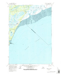
1958 Map of Tyonek A-3
USGS Topo · Published 1967About this map
Moquawkie (Tyonek) Indian Reservation anchors the southern coastline of this survey, marking a significant cultural landscape on the western shores of Cook Inlet. The map documents a rugged coastal and riverine environment where the Beluga River, Theodore River, and Lewis River empty into the inlet across extensive mud flats. Navigation and logistics in this roadless area are centered around the Beluga Landing Area and several remote landing strips, including a Winter Landing Strip near Grants Beacons. These features, along with scattered cabins and radio towers, reflect the mid-century infrastructure required for communication and transport in the Alaska wilderness. Small settlements like Ladd and geographic markers such as Cottonwood Beach and Chuit Flats provide essential reference points for researchers tracing the historical footprint of the Kenai Peninsula's western reaches.
Find a feature on this map
35 named features on this map. Tap any name to fly to it.
Don’t see what you’re looking for? This feature index may not catch every label — zoom into the map to look around manually.
Map Details
Editions of this 1958 Tyonek A-3 Map
3 editions found
Other maps of this area

1944 · Kenai
USGS Topo · 1:250,000

1949 · Tyonek
USGS Topo · 1:250,000

1950 · Kenai
USGS Topo · 1:250,000

1950 · Kenai D-4
USGS Topo · 1:63,360

1951 · Tyonek
USGS Topo · 1:250,000

1951 · Kenai D-3
USGS Topo · 1:63,360

1951 · Kenai D-2
USGS Topo · 1:63,360

1951 · Tyonek A-2
USGS Topo · 1:63,360

1952 · Kenai D-3
USGS Topo · 1:63,360

1952 · Kenai D-2
USGS Topo · 1:63,360