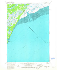
1958 Map of Tyonek A-3
USGS Topo · Published 1967About this map
The Moquawkie (Tyonek) Indian Reservation anchors the coastal landscape of this 1950s survey, marking a significant cultural and geographic point on the western shores of Cook Inlet. The terrain is defined by the heavy silt of extensive mud flats and the marshy lowlands surrounding the Beluga River and Theodore River. Human activity at this time was concentrated near the coast, centered on aviation and resource access. The Beluga Landing Area and Winter Landing Strip provided essential connectivity for remote outposts and several clusters of cabins along the riverbanks. Landmarks such as Grants Beacon and Radio Towers highlight the importance of navigation in this complex environment of lakes, including Chedatna Lakes and Viapan Lake, and shifting coastal waters near Chuit Flats.
Find a feature on this map
25 named features on this map. Tap any name to fly to it.
Don’t see what you’re looking for? This feature index may not catch every label — zoom into the map to look around manually.
Map Details
Editions of this 1958 Tyonek A-3 Map
3 editions found
Other maps of this area

1944 · Kenai
USGS Topo · 1:250,000

1949 · Tyonek
USGS Topo · 1:250,000

1950 · Kenai
USGS Topo · 1:250,000

1950 · Kenai D-4
USGS Topo · 1:63,360

1951 · Tyonek
USGS Topo · 1:250,000

1951 · Kenai D-3
USGS Topo · 1:63,360

1951 · Kenai D-2
USGS Topo · 1:63,360

1951 · Tyonek A-2
USGS Topo · 1:63,360

1952 · Kenai D-3
USGS Topo · 1:63,360

1952 · Kenai D-2
USGS Topo · 1:63,360