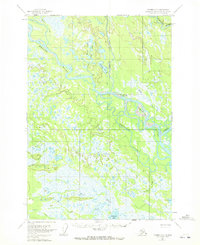
1954 Map of Tyonek D-3
USGS Topo · Published 1972About this map
The Yentna River and Kahiltna River converge in this mid-century survey of the Susitna basin, defining a landscape of complex waterways and seasonal wetlands. The settlement of McDougal (Aband) sits along the Yentna, serving as a primary human landmark in an area otherwise marked by isolated Cabins. The intricate drainage system is characterized by extensive sloughs and creek networks, including the prominent Twentymile Slough and the outlet of Alexander Lake. To the north, the Fish Lakes and Bulchitna Lake occupy the terrain between Lake Creek and the river bends. This map reflects the remote character of the Matanuska-Susitna region during the 1950s, documenting the specific locations of trapper or hunting cabins and the exact paths of salmon-bearing tributaries like Kutna Creek and Clear Creek before later 20th-century shifts in the river channels.
Find a feature on this map
18 named features on this map. Tap any name to fly to it.
Don’t see what you’re looking for? This feature index may not catch every label — zoom into the map to look around manually.
Map Details
Editions of this 1954 Tyonek D-3 Map
3 editions found
Other maps of this area

1949 · Tyonek
USGS Topo · 1:250,000

1950 · Talkeetna
USGS Topo · 1:250,000

1951 · Talkeetna
USGS Topo · 1:250,000

1951 · Tyonek
USGS Topo · 1:250,000

1954 · Tyonek D-2
USGS Topo · 1:63,360

1954 · Tyonek D-3
USGS Topo · 1:63,360

1954 · Talkeetna A-3
USGS Topo · 1:63,360

1954 · Tyonek C-4
USGS Topo · 1:63,360

1954 · Tyonek D-4
USGS Topo · 1:63,360

1954 · Talkeetna A-2
USGS Topo · 1:63,360