
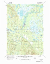
1954 Map of Tyonek D-4
USGS Topo · Published 1961About this map
Skwentna serves as the focal point of this mid-century survey, situated at the confluence where the Skwentna River meets the Yentna River. The landscape is defined by its riparian infrastructure, featuring the Skwentna Airport alongside aviation markers like a Radio Range Sta and Beacon. This era of the Alaskan interior shows a reliance on seasonal routes, evidenced by the Winter Trail cutting through the terrain west of the rivers. Historical habitation is grounded at the Old Skwentna Road House (Site), a vestige of early overland travel. To the west, the Shell Hills rise above a dense network of water bodies including Whiskey Lake and Hewitt Lake. The southern reach of the map follows the winding Talachulitna River, connecting remote points such as Hiline Lake and Top Lake.
Find a feature on this map
30 named features on this map. Tap any name to fly to it.
Don’t see what you’re looking for? This feature index may not catch every label — zoom into the map to look around manually.
Map Details
Editions of this 1954 Tyonek D-4 Map
2 editions found
Other maps of this area

1949 · Tyonek
USGS Topo · 1:250,000

1950 · Talkeetna
USGS Topo · 1:250,000

1951 · Talkeetna
USGS Topo · 1:250,000

1951 · Tyonek
USGS Topo · 1:250,000

1954 · Tyonek D-3
USGS Topo · 1:63,360

1954 · Talkeetna A-3
USGS Topo · 1:63,360

1954 · Tyonek C-5
USGS Topo · 1:63,360

1954 · Tyonek C-4
USGS Topo · 1:63,360

1954 · Tyonek D-5
USGS Topo · 1:63,360

1954 · Talkeetna A-4
USGS Topo · 1:63,360