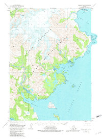
1951 Map of Ugashik A-2
USGS Topo · Published 1982About this map
Alaska National Wildlife Refuge lands dominate this coastal section of the Alaska Peninsula, where the interior's glaciated heights meet the fractured shoreline of the Pacific Ocean. Surveyed in the early 1950s, the landscape is defined by its dramatic hydrography, from the northern reach of Imuya Bay down to the sheltered waters of Port Wrangell. Numerous offshore features like David Island, Poltava I, and the isolated Lone Rock suggest the navigational complexity of these waters before modern electronic aids. The inland terrain is marked by high summits such as Icy Peak and numerous triangulation stations including VABM Snow and VABM Grip, which served as the literal foundations for mapping this unsurveyed territory. The drainage of the Agripina River into Agripina Bay highlights the primary freshwater corridors through this remote coastal wilderness.
Find a feature on this map
25 named features on this map. Tap any name to fly to it.
Don’t see what you’re looking for? This feature index may not catch every label — zoom into the map to look around manually.
Map Details
Editions of this 1951 Ugashik A-2 Map
4 editions found
Other maps of this area

1943 · Ugashik
USGS Topo · 1:250,000

1948 · Ugashik
USGS Topo · 1:250,000

1949 · Ugashik
USGS Topo · 1:250,000

1951 · Sutwik Island
USGS Topo · 1:250,000

1951 · Ugashik B-1
USGS Topo · 1:63,360

1951 · Ugashik B-3
USGS Topo · 1:63,360

1951 · Ugashik A-2
USGS Topo · 1:63,360

1951 · Ugashik B-2
USGS Topo · 1:63,360

1954 · Ugashik A-3
USGS Topo · 1:63,360

1954 · Sutwik Island D-3
USGS Topo · 1:63,360