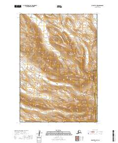
2019 Map of Ugashik B-2 NW
USGS Topo · Published 2019About this map
Kodiak Island Borough Lake and Peninsula Borough defines the administrative divide across this remote Alaskan landscape. The terrain is dominated by the prominent rise of Deer Mtn, which serves as a central landmark overlooking the surrounding drainage systems. These hydrological patterns are primarily shaped by Black Cr, which meanders through the central and southern sections, and Deer Cr, which flows through the northeastern corner. This 2019 survey captures the area's transition between the two boroughs, providing a detailed look at the topographic contours and watershed boundaries in a region defined more by its physical geography than by human settlement.
Find a feature on this map
8 named features on this map. Tap any name to fly to it.
Don’t see what you’re looking for? This feature index may not catch every label — zoom into the map to look around manually.
Map Details
Editions of this 2019 Ugashik B-2 NW Map
This is the sole edition of this map. No revisions or reprints were ever made.
Other maps of this area

1943 · Ugashik
USGS Topo · 1:250,000

1948 · Ugashik
USGS Topo · 1:250,000

1949 · Ugashik
USGS Topo · 1:250,000

1951 · Ugashik B-3
USGS Topo · 1:63,360

1951 · Ugashik C-2
USGS Topo · 1:63,360

1951 · Ugashik C-3
USGS Topo · 1:63,360

1951 · Ugashik B-2
USGS Topo · 1:63,360

1963 · Ugashik
USGS Topo · 1:250,000
2019 · Ugashik C-2 SE
USGS Topo · 1:25,000
2019 · Ugashik B-2 SW
USGS Topo · 1:25,000