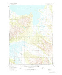
1951 Map of Ugashik B-3
USGS Topo · Published 1975About this map
The Dog Salmon River meanders through this wilderness of the Alaska Peninsula, defining a landscape of complex hydrology as it was mapped in the early 1950s. The northern reaches of the quadrangle are dominated by the expanse of Lower Ugashik Lake, which transitions into a system of smaller alpine waters such as Elizabeth Lake and Lenore Lake. Between these lakes and the winding course of Figure Eight Creek, the terrain rises toward unnamed peaks, reflecting the unsurveyed and unmarked land lines noted by the Bureau of Land Management. A single Cabin stands near the confluence of Goblet Creek, marking one of the few signs of human presence in a region primarily shaped by its drainage networks, including Black Creek and the broader watershed feeding into the Bristol Bay drainage. This map documents a period before modern development, where topographic details were derived from aerial photography and the USCE's early control points.
Find a feature on this map
8 named features on this map. Tap any name to fly to it.
Don’t see what you’re looking for? This feature index may not catch every label — zoom into the map to look around manually.
Map Details
Editions of this 1951 Ugashik B-3 Map
3 editions found
Other maps of this area

1943 · Ugashik
USGS Topo · 1:250,000

1948 · Ugashik
USGS Topo · 1:250,000

1949 · Ugashik
USGS Topo · 1:250,000

1951 · Ugashik C-4
USGS Topo · 1:63,360

1951 · Ugashik B-3
USGS Topo · 1:63,360

1951 · Ugashik C-2
USGS Topo · 1:63,360

1951 · Ugashik C-3
USGS Topo · 1:63,360

1951 · Ugashik A-2
USGS Topo · 1:63,360

1951 · Ugashik B-2
USGS Topo · 1:63,360

1954 · Ugashik A-3
USGS Topo · 1:63,360