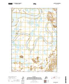
2019 Map of Ugashik B-5 NE
USGS Topo · Published 2019About this map
Ugashik River dominates the northern reaches of this landscape, winding through a complex network of wetlands and oxbow lakes characteristic of the Alaska Peninsula. Further south, the meandering course of the Dog Salmon River carves through the terrain, illustrating the dynamic hydrology of the Lake and Peninsula Borough. This map reveals a region defined by its water systems and lacks permanent human settlements or infrastructure, offering a pristine view of the natural drainage patterns within townships like t31s r50w and t32s r51w. The intricate branching of the river channels and the surrounding marshy lowlands highlight a landscape shaped by seasonal shifts and untouched by industrial development.
Find a feature on this map
6 named features on this map. Tap any name to fly to it.
Don’t see what you’re looking for? This feature index may not catch every label — zoom into the map to look around manually.
Map Details
Editions of this 2019 Ugashik B-5 NE Map
This is the sole edition of this map. No revisions or reprints were ever made.
Other maps of this area

1943 · Ugashik
USGS Topo · 1:250,000

1948 · Ugashik
USGS Topo · 1:250,000

1949 · Ugashik
USGS Topo · 1:250,000

1951 · Ugashik C-5
USGS Topo · 1:63,360

1951 · Ugashik C-4
USGS Topo · 1:63,360

1954 · Ugashik B-4
USGS Topo · 1:63,360

1954 · Ugashik B-5
USGS Topo · 1:63,360

1963 · Ugashik
USGS Topo · 1:250,000
2019 · Ugashik C-4 SW
USGS Topo · 1:25,000
2019 · Ugashik B-5 SW
USGS Topo · 1:25,000