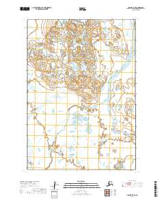
2019 Map of Ugashik B-6 SE
USGS Topo · Published 2019About this map
The King Salmon River flows through this remote stretch of the Alaska Peninsula, defining the eastern drainage of a landscape dominated by complex hydrography and low-lying wetlands. In this 2019 survey, the meandering course of Pumice Creek cuts through the western sections, eventually turning eastward to join the larger river system. This region is characterized by its lack of permanent settlements or infrastructure, as shown by the absence of roads and buildings on the sheet. The terrain is instead defined by the intricate networks of small ponds and unnamed tributaries that feed into Old Cr and the primary river valleys. For researchers of the Lake and Peninsula Borough, this map provides a precise record of the shifting hydrological patterns and township boundaries, including t33s r53w and t32s r52w, in a pristine subarctic environment.
Find a feature on this map
9 named features on this map. Tap any name to fly to it.
Don’t see what you’re looking for? This feature index may not catch every label — zoom into the map to look around manually.
Map Details
Editions of this 2019 Ugashik B-6 SE Map
This is the sole edition of this map. No revisions or reprints were ever made.
Other maps of this area

1943 · Ugashik
USGS Topo · 1:250,000

1948 · Ugashik
USGS Topo · 1:250,000

1949 · Ugashik
USGS Topo · 1:250,000

1954 · Ugashik B-5
USGS Topo · 1:63,360

1963 · Ugashik B-6
USGS Topo · 1:63,360

1963 · Ugashik A-6
USGS Topo · 1:63,360
1963 · Ugashik A-5
USGS Topo · 1:63,360

1963 · Ugashik
USGS Topo · 1:250,000
2019 · Ugashik B-5 SW
USGS Topo · 1:25,000
2019 · Ugashik A-6 NE
USGS Topo · 1:25,000