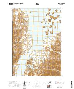
2019 Map of Ugashik C-1 NE
USGS Topo · Published 2019About this map
Becharof Lake dominates this coastal Alaska landscape, where the waters of the lake nearly meet the tidal reach of Bellim Bay. The terrain is defined by a series of significant drainage systems, including Salmon Cr, Bear Cr, and Burls Cr, which carve through the elevations of the Lake and Peninsula Borough. A distinctive landmark, Seal Point, sits at the mouth of the bay, marking a transition between the inland freshwater environment and the maritime influences of the coast. The mapping of these waterways and points of land provides an essential record of the region’s complex hydrography, showing how local streams like Otter Cr and Camp Cr feed into the larger bodies of water that define the area’s geography.
Find a feature on this map
12 named features on this map. Tap any name to fly to it.
Don’t see what you’re looking for? This feature index may not catch every label — zoom into the map to look around manually.
Map Details
Editions of this 2019 Ugashik C-1 NE Map
This is the sole edition of this map. No revisions or reprints were ever made.
Other maps of this area

1943 · Ugashik
USGS Topo · 1:250,000

1948 · Ugashik
USGS Topo · 1:250,000

1949 · Ugashik
USGS Topo · 1:250,000

1951 · Karluk
USGS Topo · 1:250,000

1951 · Ugashik D-1
USGS Topo · 1:63,360

1951 · Ugashik C-1
USGS Topo · 1:63,360

1951 · Karluk D-6
USGS Topo · 1:63,360
1951 · Karluk C-6
USGS Topo · 1:63,360

1952 · Karluk
USGS Topo · 1:250,000

1963 · Ugashik
USGS Topo · 1:250,000