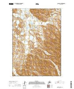
2019 Map of Ugashik C-2 SW
USGS Topo · Published 2019About this map
Deer Cr and Crooked Cr wind through this remote Alaskan landscape in the Lake and Peninsula borough, illustrating the hydrological patterns of the Bristol Bay region. This 2019 survey, published by the U.S. Geological Survey, details the elevation changes across several townships including t30s r46w, t30s r45w, and t31s r45w. The map reveals a transition from wetland-rich lowlands in the northwest to more significant topographic relief in the southeast. While devoid of named settlements or roads, the intricate contour lines and drainage patterns of Crooked Cr and its tributaries provide a precise view of the terrain for modern navigation and geographic study.
Find a feature on this map
5 named features on this map. Tap any name to fly to it.
Don’t see what you’re looking for? This feature index may not catch every label — zoom into the map to look around manually.
Map Details
Editions of this 2019 Ugashik C-2 SW Map
This is the sole edition of this map. No revisions or reprints were ever made.
Other maps of this area

1943 · Ugashik
USGS Topo · 1:250,000

1948 · Ugashik
USGS Topo · 1:250,000

1949 · Ugashik
USGS Topo · 1:250,000

1951 · Ugashik B-3
USGS Topo · 1:63,360

1951 · Ugashik C-2
USGS Topo · 1:63,360

1951 · Ugashik C-3
USGS Topo · 1:63,360

1951 · Ugashik B-2
USGS Topo · 1:63,360

1963 · Ugashik
USGS Topo · 1:250,000
2019 · Ugashik C-2 SE
USGS Topo · 1:25,000
2019 · Ugashik C-3 SE
USGS Topo · 1:25,000