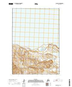
2019 Map of Ugashik D-1 SW
USGS Topo · Published 2019About this map
The northern reaches of the Aleutian Range dominate this part of the Alaska Peninsula, where the mountainous terrain meets the expansive waters of Becharof Lake. The landscape transition is marked by a series of glacial and hydrological features, including the southward-flowing Featherly Cr which drains the high elevations. This area is characterized by the absence of permanent human settlements or infrastructure, illustrating the wilderness state of the Lake and Peninsula Borough. The topography shown reflects the complex shoreline along the southern edge of the lake and the steep rise into the volcanic range, serving as a record of one of the most remote geological environments in North America.
Find a feature on this map
7 named features on this map. Tap any name to fly to it.
Don’t see what you’re looking for? This feature index may not catch every label — zoom into the map to look around manually.
Map Details
Editions of this 2019 Ugashik D-1 SW Map
This is the sole edition of this map. No revisions or reprints were ever made.
Other maps of this area

1943 · Ugashik
USGS Topo · 1:250,000

1948 · Ugashik
USGS Topo · 1:250,000

1949 · Ugashik
USGS Topo · 1:250,000

1951 · Ugashik D-1
USGS Topo · 1:63,360

1951 · Ugashik C-1
USGS Topo · 1:63,360

1951 · Ugashik C-2
USGS Topo · 1:63,360

1951 · Ugashik D-2
USGS Topo · 1:63,360

1963 · Ugashik
USGS Topo · 1:250,000
2019 · Ugashik D-1 SE
USGS Topo · 1:25,000
2019 · Ugashik D-1 NW
USGS Topo · 1:25,000