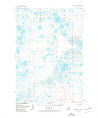
1951 Map of Ugashik D-4
USGS Topo · Published 1977About this map
Hydrological patterns and low-lying wetlands dominate this mid-century survey of the Alaska Peninsula. Based on 1951 aerial photography, the landscape is defined by an intricate network of unnamed lakes and marshy basins that illustrate the region's complex drainage. A single Landing Strip serves as the only evidence of human infrastructure in this section of the quadrangle, reflecting the critical role of bush aviation in navigating and accessing the remote interior during the early post-war period. The absence of roads or established settlements emphasizes the reliance on natural terrain and seasonal conditions for movement across this part of the Lake and Peninsula territory.
Find a feature on this map
1 named feature on this map. Tap any name to fly to it.
Don’t see what you’re looking for? This feature index may not catch every label — zoom into the map to look around manually.
Map Details
Editions of this 1951 Ugashik D-4 Map
2 editions found
Other maps of this area

1943 · Ugashik
USGS Topo · 1:250,000

1948 · Ugashik
USGS Topo · 1:250,000

1949 · Ugashik
USGS Topo · 1:250,000

1951 · Ugashik C-5
USGS Topo · 1:63,360

1951 · Ugashik C-4
USGS Topo · 1:63,360

1951 · Ugashik D-5 and D-6
USGS Topo · 1:63,360

1951 · Ugashik D-3
USGS Topo · 1:63,360

1951 · Ugashik D-4
USGS Topo · 1:63,360

1951 · Naknek A-5
USGS Topo · 1:63,360

1951 · Naknek A-4
USGS Topo · 1:63,360