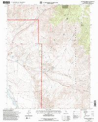
1994 Map of Uhlmeyer Spring
USGS Topo · Published 1997About this map
The high desert landscape of Inyo National Forest is defined here by the convergence of the White Mountains and the Inyo Mountains, separated by deep cuts like Soldier Canyon and Crooked Canyon. This 1990s revision reveals a terrain where water is the most critical resource, evidenced by the strategic locations of Uhlmeyer Spring, Wilkerson Springs, and Batchelder Spring.
Find a feature on this map
20 named features on this map. Tap any name to fly to it.
Don’t see what you’re looking for? This feature index may not catch every label — zoom into the map to look around manually.
Map Details
Editions of this 1994 Uhlmeyer Spring Map
2 editions found
Other maps of this area

1913 · Bishop
USGS Topo · 1:125,000

1947 · Mariposa
USGS Topo · 1:250,000

1948 · Mariposa
USGS Topo · 1:250,000

1949 · Bishop
USGS Topo · 1:62,500

1950 · Big Pine
USGS Topo · 1:62,500

1951 · Bishop
USGS Topo · 1:62,500

1951 · Blanco Mountain
USGS Topo · 1:62,500

1951 · Waucoba Mtn.
USGS Topo · 1:62,500

1957 · Mariposa
USGS Topo · 1:250,000
1958 · Waucoba Mtn
USGS Topo · 1:62,500