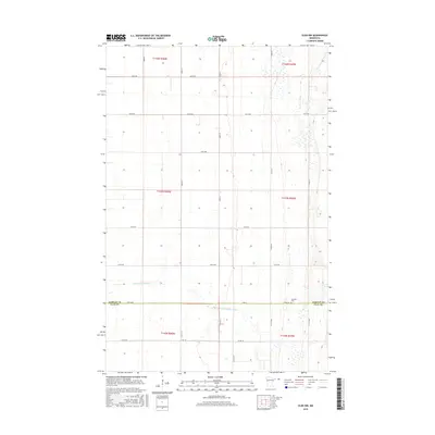
2016 Map of Ulen NW
USGS Topo · Published 2016About this map
The S Br Wild Rice River meanders across the flat agricultural landscape of the Red River Valley, carving a gentle course through the borderlands of Norman Co and Clay Co. This 2016 survey illustrates the precision of the Public Land Survey System, with a rigid grid of gravel roads and section lines defining the rural character of the region. The map reveals the meticulous division of townships, including t143n r45w and t142n r46w, where massive tracts of farmland are punctuated only by occasional farmstead windbreaks and drainage patterns. Near the southern county line, the Jevnaker Cem serves as a small but significant landmark for local genealogy, marking a historical point of community assembly in this sparsely settled prairie expanse. The road network, comprising routes like Co Rd 102 and 160th Ave, reflects the enduring infrastructure of Minnesota's wheat and sugar beet country.
Find a feature on this map
29 named features on this map. Tap any name to fly to it.
Don’t see what you’re looking for? This feature index may not catch every label — zoom into the map to look around manually.
Map Details
Editions of this 2016 Ulen NW Map
This is the sole edition of this map. No revisions or reprints were ever made.
Other maps of this area

1918 · Twin Valley
USGS Topo · 1:62,500

1918 · Ulen
USGS Topo · 1:62,500

1924 · Ada
USGS Topo · 1:62,500

1952 · Grand Forks
USGS Topo · 1:250,000

1956 · Grand Forks
USGS Topo · 1:250,000

1965 · Twin Valley SW
USGS Topo · 1:24,000

1965 · Twin Valley
USGS Topo · 1:24,000

1965 · Syre
USGS Topo · 1:24,000
1965 · Ada
USGS Topo · 1:24,000
1965 · Ulen NW
USGS Topo · 1:24,000