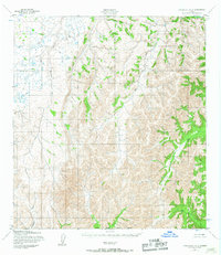
1952 Map of Unalakleet A-5
USGS Topo · Published 1967About this map
The Golsovia River flows northward through the western reaches of this 1950s interior Alaskan landscape, which was mapped by the Army Map Service using early photogrammetric methods. This remote quadrangle is defined by its complex drainage networks, where the Atchuelinguk River and Beaver Creek dominate the southern terrain. The survey captures the natural state of the Seward Meridian before significant modern development, emphasizing the topographical prominence of unnamed ridges separated by the Swift River and Otter Creek. The alignment of the North Boundary Seward Meridian provides a critical geographic reference point for this subarctic region, which remained largely unroaded and unsurveyed on the ground at the time of the 1952 field annotation.
Find a feature on this map
6 named features on this map. Tap any name to fly to it.
Don’t see what you’re looking for? This feature index may not catch every label — zoom into the map to look around manually.
Map Details
Editions of this 1952 Unalakleet A-5 Map
3 editions found
Other maps of this area

1951 · Unalakleet
USGS Topo · 1:250,000

1951 · Holy Cross
USGS Topo · 1:250,000

1952 · Unalakleet A-4
USGS Topo · 1:63,360

1952 · Unalakleet A-5
USGS Topo · 1:63,360

1952 · Unalakleet B-4
USGS Topo · 1:63,360

1952 · Unalakleet B-6
USGS Topo · 1:63,360

1952 · Holy Cross D-5
USGS Topo · 1:63,360

1952 · Holy Cross D-4
USGS Topo · 1:63,360

1952 · Unalakleet B-5
USGS Topo · 1:63,360

1952 · Unalakleet A-6
USGS Topo · 1:63,360