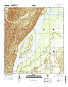
2015 Map of Unalakleet B-2 SE
USGS Topo · Published 2015About this map
The Yukon River dominates this interior landscape, weaving through a complex network of side channels and wetlands. Central to this stretch of the river is Alice Island, a significant landform situated where the main channel meets a labyrinth of smaller waterways. The drainage pattern is defined by Saint Joe Creek and the southern reaches of Yankee Slough, illustrating the dynamic nature of the river's floodplains. To the northwest, the terrain rises sharply from the riverbank, with the headwaters of Blackburn Cr cutting through the higher elevations. This 2015 U.S. Geological Survey representation documents the shifting hydrology of the Yukon-Koyukuk region, capturing the intricate relationship between the primary river artery and its seasonal distributaries.
Find a feature on this map
14 named features on this map. Tap any name to fly to it.
Don’t see what you’re looking for? This feature index may not catch every label — zoom into the map to look around manually.
Map Details
Editions of this 2015 Unalakleet B-2 SE Map
This is the sole edition of this map. No revisions or reprints were ever made.
Other maps of this area

1951 · Unalakleet
USGS Topo · 1:250,000

1952 · Unalakleet A-2
USGS Topo · 1:63,360

1952 · Unalakleet A-1
USGS Topo · 1:63,360

1952 · Unalakleet B-2
USGS Topo · 1:63,360

1952 · Unalakleet B-1
USGS Topo · 1:63,360

1952 · Unalakleet
USGS Topo · 1:250,000

1964 · Unalakleet
USGS Topo · 1:250,000
2015 · Unalakleet B-2 NW
USGS Topo · 1:25,000
2015 · Unalakleet B-1 SW
USGS Topo · 1:25,000
2015 · Unalakleet B-2 SW
USGS Topo · 1:25,000