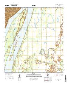
2015 Map of Unalakleet C-1 SW
USGS Topo · Published 2015About this map
The Yukon River dominates this portion of the interior, carving a wide path through the low-lying terrain of the Yukon-Koyukuk region. In the northwestern corner, Guide Point and the elevations near Eagle Island overlook the shifting channels and sandbars of the river's braided course. These features illustrate the dynamic nature of the waterway as it moves through the expansive river valley, where seasonal changes and sedimentation constantly reshape the banks. To the southeast, the meandering Papa Willie Creek winds through a complex network of wetlands and smaller drainage patterns. This survey, produced from data gathered by the Alaska Dept. of Transportation and the BLM, provides a clear view of the township and range lines across this remote stretch of Alaskan wilderness.
Find a feature on this map
10 named features on this map. Tap any name to fly to it.
Don’t see what you’re looking for? This feature index may not catch every label — zoom into the map to look around manually.
Map Details
Editions of this 2015 Unalakleet C-1 SW Map
This is the sole edition of this map. No revisions or reprints were ever made.
Other maps of this area

1951 · Unalakleet
USGS Topo · 1:250,000

1952 · Unalakleet C-2
USGS Topo · 1:63,360

1952 · Unalakleet C-1
USGS Topo · 1:63,360

1952 · Unalakleet B-2
USGS Topo · 1:63,360

1952 · Unalakleet B-1
USGS Topo · 1:63,360

1952 · Unalakleet
USGS Topo · 1:250,000

1964 · Unalakleet
USGS Topo · 1:250,000
2015 · Unalakleet C-2 NE
USGS Topo · 1:25,000
2015 · Unalakleet C-1 SE
USGS Topo · 1:25,000
2015 · Unalakleet C-1 NE
USGS Topo · 1:25,000