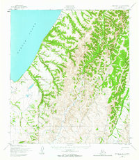
1952 Map of Unalakleet C-4
USGS Topo · Published 1963About this map
Norton Sound defines the western edge of this coastal landscape, where the tides meet a network of intricate drainages and seasonal routes. The interior is dominated by the South Fork Unalakleet River and the Chiroskey River, which snake through the territory toward the coast. Of particular interest to historical researchers is the Winter Trail, which provides a window into the traditional transportation corridors used when the ground was frozen, long before modern infrastructure reached this part of the Seward Peninsula region.
Find a feature on this map
17 named features on this map. Tap any name to fly to it.
Don’t see what you’re looking for? This feature index may not catch every label — zoom into the map to look around manually.
Map Details
Editions of this 1952 Unalakleet C-4 Map
2 editions found
Other maps of this area

1950 · Unalakleet D-3
USGS Topo · 1:63,360

1950 · Unalakleet D-4
USGS Topo · 1:63,360

1951 · Unalakleet
USGS Topo · 1:250,000

1952 · Unalakleet B-4
USGS Topo · 1:63,360

1952 · Unalakleet C-3
USGS Topo · 1:63,360

1952 · Unalakleet C-4
USGS Topo · 1:63,360

1952 · Unalakleet B-3
USGS Topo · 1:63,360

1952 · Unalakleet B-5
USGS Topo · 1:63,360
1952 · Unalakleet C-5
USGS Topo · 1:63,360

1952 · Unalakleet
USGS Topo · 1:250,000