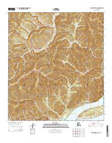
2015 Map of Unalakleet D-1 SW
USGS Topo · Published 2015About this map
The Yukon River carves through the southeastern corner of this Alaskan interior landscape, flowing past the low-lying Eagle Island. This section of the river is framed by the dramatic eastern edges of the Nulato Hills, which dominate the terrain with their complex ridgelines and steep drainage basins. To the north, Stink Cr winds through these elevations, eventually feeding into larger riparian systems. The topography is defined by significant elevation changes, most notably at the Eagle Slide, where the hills meet the river corridor. This 2015 survey provides a clear view of the natural hydrology and undeveloped wilderness prior to recent shifts in the regional environment.
Find a feature on this map
9 named features on this map. Tap any name to fly to it.
Don’t see what you’re looking for? This feature index may not catch every label — zoom into the map to look around manually.
Map Details
Editions of this 2015 Unalakleet D-1 SW Map
This is the sole edition of this map. No revisions or reprints were ever made.
Other maps of this area

1951 · Unalakleet
USGS Topo · 1:250,000

1952 · Unalakleet C-2
USGS Topo · 1:63,360

1952 · Unalakleet D-2
USGS Topo · 1:63,360

1952 · Unalakleet C-1
USGS Topo · 1:63,360

1952 · Unalakleet D-1
USGS Topo · 1:63,360

1952 · Unalakleet
USGS Topo · 1:250,000

1964 · Unalakleet
USGS Topo · 1:250,000
2015 · Unalakleet C-2 NE
USGS Topo · 1:25,000
2015 · Unalakleet C-1 NE
USGS Topo · 1:25,000
2015 · Unalakleet D-1 SE
USGS Topo · 1:25,000