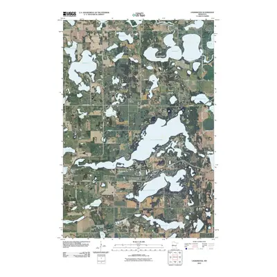
2010 Map of Underwood
USGS Topo · Published 2010About this map
Underwood serves as the primary community hub in this lake-heavy portion of Otter Tail County, located at the junction of County Hwy-35 and County Hwy-122. The landscape is defined by its glacial hydrology, featuring large water bodies such as North Turtle Lake and South Turtle Lake, along with the winding course of the Otter Tail River in the northeast and the Pomme de Terre River in the south. For those tracing family roots in the region, the map identifies several distinct burial grounds including Sverdrup Cemetery, Tingvold Cemetery, and the Sunset Memorial Unitarian Cemetery. Further south, the Norwegian Methodist Episcopal Church remains a significant landmark near Long Lake. The map's network of rural roads like Pony Rd and Turkey Loop illustrates the dense integration of residential lake properties and agricultural land typical of early 21st-century Minnesota lake country.
Find a feature on this map
63 named features on this map. Tap any name to fly to it.
Don’t see what you’re looking for? This feature index may not catch every label — zoom into the map to look around manually.
Map Details
Editions of this 2010 Underwood Map
This is the sole edition of this map. No revisions or reprints were ever made.
Other maps of this area

1912 · Battle Lake
USGS Topo · 1:62,500

1913 · Ashby
USGS Topo · 1:62,500

1914 · Battle Lake
USGS Topo · 1:62,500

1915 · Underwood
USGS Topo · 1:62,500

1953 · Brainerd
USGS Topo · 1:250,000

1957 · Brainerd
USGS Topo · 1:250,000

1958 · Brainerd
USGS Topo · 1:250,000

1965 · Brainerd
USGS Topo · 1:250,000

1969 · Eagle Lake
USGS Topo · 1:24,000
1973 · Battle Lake
USGS Topo · 1:24,000
Featured Places
- Underwood, MN
- Everts Township, MN
- Tordenskjold Township, MN
- Clitherall Township, MN
- Sverdrup Township, MN