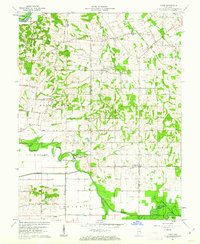
1961 Map of Union
USGS Topo · Published 1963About this map
The Patoka River and White River define the hydraulic character of this southwestern Indiana landscape, where the flatlands of Dead Level meet the low-lying wetlands of Goose Creek. Small rural settlements like Union and Mount Olympus serve as local anchors, connected by a network of named country roads such as Salem Road and John Ford Road. The map reveals a land utilized for both conservation and extraction, featuring a portion of the Pike County State Forest alongside an active Oil Field in the southern portion of the quadrangle. Genealogists will find a dense distribution of family and community landmarks, from Bethlehem Cem and Armstrong Cem to several local congregations, including Atkinson Chapel and Little Zion Ch, reflecting the deep-rooted social fabric of the early 1960s.
Find a feature on this map
66 named features on this map. Tap any name to fly to it.
Don’t see what you’re looking for? This feature index may not catch every label — zoom into the map to look around manually.
Map Details
Editions of this 1961 Union Map
3 editions found
Other maps of this area

1901 · Princeton
USGS Topo · 1:62,500

1902 · Ditney
USGS Topo · 1:125,000

1903 · Petersburg
USGS Topo · 1:62,500

1903 · Princeton
USGS Topo · 1:62,500

1903 · Patoka
USGS Topo · 1:125,000

1915 · Vincennes
USGS Topo · 1:62,500

1944 · Monroe City
USGS Topo · 1:24,000

1944 · Iona
USGS Topo · 1:24,000

1944 · Vincennes
USGS Topo · 1:62,500

1956 · Vincennes
USGS Topo · 1:250,000