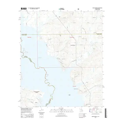
2015 Map of Union Springs
USGS Topo · Published 2015About this map
Union Springs and the surrounding piney woods of East Texas and Western Louisiana are defined by the winding eastern shoreline of the Toledo Bend Reservoir. This survey illustrates the intricate interface between the water and the rising terrain of the Sabine National Forest, where numerous inlets like Bull Bayou and Bear Creek carve into the landscape. The map provides significant genealogical value through its marking of local burial sites such as Bossier Cemetery and Pauls Cemetery. To the south, the settlement of Huxley sits near the water’s edge, while the interior landscape reveals distinctive open areas such as Racetrack Prairie and Gravel Prairie. The presence of a Gravel Pit and numerous forest roads, including Fire Lane Road and Nubbin Ridge Road, reflects the region's historical reliance on timber and extractive industries.
Find a feature on this map
70 named features on this map. Tap any name to fly to it.
Don’t see what you’re looking for? This feature index may not catch every label — zoom into the map to look around manually.
Map Details
Editions of this 2015 Union Springs Map
This is the sole edition of this map. No revisions or reprints were ever made.
Other maps of this area

1941 · Zwolle
USGS Topo · 1:62,500

1941 · Pelican
USGS Topo · 1:62,500

1943 · Pleasant Hill
USGS Topo · 1:62,500

1944 · Logansport
USGS Topo · 1:62,500

1944 · Patroon
USGS Topo · 1:62,500

1944 · Zwolle
USGS Topo · 1:62,500

1944 · Pleasant Hill
USGS Topo · 1:62,500

1953 · Alexandria
USGS Topo · 1:250,000

1955 · Alexandria
USGS Topo · 1:250,000

1956 · Logansport
USGS Topo · 1:62,500