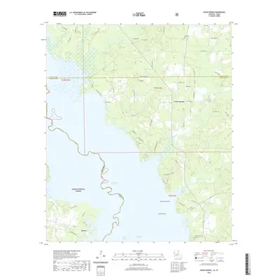
2020 Map of Union Springs
USGS Topo · Published 2020About this map
The Toledo Bend Reservoir dominates this borderland landscape where the Texas and Louisiana state lines meet amidst the dense woodlands of the Sabine National Forest. The map documents the intricate network of inlets and sloughs including Kilgore Slough and Soto Saline Slough, which define the western shoreline near the settlement of Huxley. On the eastern side of the water, the terrain rises toward Union Springs and is characterized by distinct natural clearings such as Racetrack Prairie and Gravel Prairie. Local history is anchored by family and community landmarks like Pauls Cem and Oak Grove Church Cem. The map provides a clear look at how bayous like Augustine Bayou and Moccasin Bayou feed into the reservoir system, creating a complex interface between the managed forest and the sprawling waterway.
Find a feature on this map
75 named features on this map. Tap any name to fly to it.
Don’t see what you’re looking for? This feature index may not catch every label — zoom into the map to look around manually.
Map Details
Editions of this 2020 Union Springs Map
This is the sole edition of this map. No revisions or reprints were ever made.
Other maps of this area

1941 · Zwolle
USGS Topo · 1:62,500

1941 · Pelican
USGS Topo · 1:62,500

1943 · Pleasant Hill
USGS Topo · 1:62,500

1944 · Logansport
USGS Topo · 1:62,500

1944 · Patroon
USGS Topo · 1:62,500

1944 · Zwolle
USGS Topo · 1:62,500

1944 · Pleasant Hill
USGS Topo · 1:62,500

1953 · Alexandria
USGS Topo · 1:250,000

1955 · Alexandria
USGS Topo · 1:250,000

1956 · Logansport
USGS Topo · 1:62,500