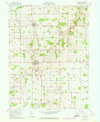
1961 Map of Uniopolis
USGS Topo · Published 1972About this map
The Auglaize River cuts through the northwest corner of this agricultural landscape, where the historical Indian Treaty Boundary and Old Indian Treaty Boundary still define the layout of the land across Union and Pusheta townships. In the early 1960s, the village of Uniopolis served as a central hub, flanked by the Detroit Toledo and Ironton railroad. The map preserves the locations of several small settlements and railway stops, including St Johns, Geyer, and Slater, which grew along the local transit corridors.
Find a feature on this map
67 named features on this map. Tap any name to fly to it.
Don’t see what you’re looking for? This feature index may not catch every label — zoom into the map to look around manually.
Map Details
Editions of this 1961 Uniopolis Map
Other maps of this area

1906 · Lima
USGS Topo · 1:62,500

1913 · Alger
USGS Topo · 1:48,000

1913 · Bellefontaine
USGS Topo · 1:48,000

1913 · Sidney
USGS Topo · 1:62,500

1915 · Alger
USGS Topo · 1:62,500

1915 · Bellefontaine
USGS Topo · 1:62,500

1943 · Alger
USGS Topo · 1:62,500

1944 · Sidney
USGS Topo · 1:62,500

1944 · Bellefontaine
USGS Topo · 1:62,500

1950 · Marion
USGS Topo · 1:250,000