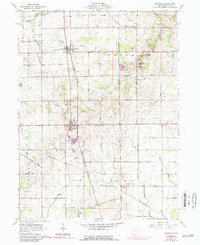
1961 Map of Uniopolis
USGS Topo · Published 1989About this map
The Old Indian Treaty Boundary slices through this section of Auglaize County, marking a significant historical line in the settlement of western Ohio. The landscape is defined by the industrial and agricultural rhythm of the early 1960s, centered on the villages of Uniopolis and St Johns. Transportation dominates the layout, with the Detroit Toledo and Ironton RR running north-south through Slater and Gutman, while the Penn Central line traverses the southern reaches near Geyer.
Find a feature on this map
49 named features on this map. Tap any name to fly to it.
Don’t see what you’re looking for? This feature index may not catch every label — zoom into the map to look around manually.
Map Details
Editions of this 1961 Uniopolis Map
Other maps of this area

1906 · Lima
USGS Topo · 1:62,500

1913 · Alger
USGS Topo · 1:48,000

1913 · Bellefontaine
USGS Topo · 1:48,000

1913 · Sidney
USGS Topo · 1:62,500

1915 · Alger
USGS Topo · 1:62,500

1915 · Bellefontaine
USGS Topo · 1:62,500

1943 · Alger
USGS Topo · 1:62,500

1944 · Sidney
USGS Topo · 1:62,500

1944 · Bellefontaine
USGS Topo · 1:62,500

1950 · Marion
USGS Topo · 1:250,000