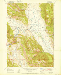
1951 Map of Upper Valley
USGS Topo · Published 1951About this map
Stocking Ranch and the Trail Guard Sta serve as the primary human markers in this high-elevation landscape of the Caribou National Forest. The geography is defined by parallel northwest-trending ridges including Rasmussen Ridge, the Webster Range, and the Wooley Range, which dictate the drainage patterns of the Blackfoot River and Lanes Creek. Several unnamed prospects suggest early mineral exploration across Rasmussen Valley and Dry Valley. The river carves through a tight topographic constriction known as The Narrows, while more remote stretches of the Upper Valley are fed by numerous small tributaries like Angus Creek and Diamond Creek. This 1949 survey provides a precise view of the region's topography before more modern developments, preserving the locations of cattle-range improvements and early forest service infrastructure.
Find a feature on this map
43 named features on this map. Tap any name to fly to it.
Don’t see what you’re looking for? This feature index may not catch every label — zoom into the map to look around manually.
Map Details
Editions of this 1951 Upper Valley Map
4 editions found
Other maps of this area

1911 · Slug Creek
USGS Topo · 1:62,500

1915 · Freedom
USGS Topo · 1:62,500

1915 · Crow Creek
USGS Topo · 1:62,500

1915 · Lanes Creek
USGS Topo · 1:62,500

1949 · Johnson Creek
USGS Topo · 1:24,000

1949 · Stewart Flat
USGS Topo · 1:24,000

1949 · Dry Valley
USGS Topo · 1:24,000

1949 · Lower Valley
USGS Topo · 1:24,000

1951 · Lower Valley
USGS Topo · 1:24,000
1951 · Upper Valley
USGS Topo · 1:24,000