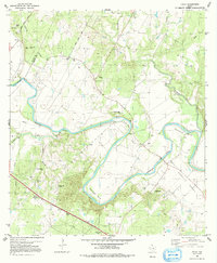
1982 Map of Utley
USGS Topo · Published 1991About this map
The meandering Colorado River defines the landscape of this Central Texas survey, carving deep oxbows through the terrain at Pope Bend, Wilbarger Bend, and Hemphill Bend. Along the boundary between Travis and Bastrop Counties, the small community of Utley sits near the river's edge, while Cedar Valley lies further north. This 1982 revision shows a rural environment where local history is anchored by numerous small burial grounds and churches, such as Hill Cem, St Paul Cem, and the Williams Cemetery.
Find a feature on this map
34 named features on this map. Tap any name to fly to it.
Don’t see what you’re looking for? This feature index may not catch every label — zoom into the map to look around manually.
Map Details
Editions of this 1982 Utley Map
3 editions found
Other maps of this area

1885 · Bastrop
USGS Topo · 1:125,000

1893 · Bastrop
USGS Topo · 1:125,000

1896 · Austin
USGS Topo · 1:125,000

1897 · Austin
USGS Topo · 1:125,000

1904 · Bastrop
USGS Topo · 1:125,000

1910 · Austin
USGS Topo · 1:125,000

1948 · Elgin
USGS Topo · 1:62,500

1948 · Bastrop
USGS Topo · 1:62,500

1950 · Bastrop
USGS Topo · 1:62,500

1950 · Elgin
USGS Topo · 1:62,500