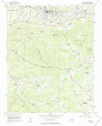
1956 Map of Valdese
USGS Topo · Published 1984About this map
Valdese and its surrounding textile-town neighbors sit along the ridge-top route of the Southern railroad, where industrial development meets the rising foothills of the Blue Ridge. The landscape transitions sharply from the built-up corridor of Drexel and Rutherford College in the north to the heavily dissected terrain of the South Mountains in the south. This 1956 field check documents a dense network of rural community landmarks, particularly the numerous country churches like Bollingers Chapel and Warlicks Chapel that served isolated farmsteads and milling families.
Find a feature on this map
61 named features on this map. Tap any name to fly to it.
Don’t see what you’re looking for? This feature index may not catch every label — zoom into the map to look around manually.
Map Details
Editions of this 1956 Valdese Map
2 editions found
Other maps of this area

1895 · Hickory
USGS Topo · 1:125,000

1905 · Morganton
USGS Topo · 1:125,000

1953 · Charlotte
USGS Topo · 1:250,000

1954 · Charlotte
USGS Topo · 1:250,000

1956 · Valdese
USGS Topo · 1:24,000

1956 · Benn Knob
USGS Topo · 1:24,000

1956 · Morganton North
USGS Topo · 1:24,000

1956 · Casar
USGS Topo · 1:24,000

1956 · Morganton South
USGS Topo · 1:24,000

1956 · Drexel
USGS Topo · 1:24,000