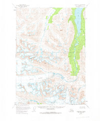
1951 Map of Valdez B-5
USGS Topo · Published 1975About this map
The Tonsina Glacier dominates the southern landscape of this 1951 survey, a massive ice field defined by its extensive Crevasses that feed the Tonsina River. The valley below reveals a classic glacial drainage pattern, where the river flows north through the deep Tonsina Lake before continuing its course alongside smaller tributaries like Hurtle Creek. To the southwest, the Tsina Glacier and the headwaters of the Tsina River highlight the complex hydrological divide of this Alaskan interior. This map, based on aerial photography from 1950 and 1957, captures the area during a period of intense photogrammetric mapping. It documents the pristine state of the watershed and the alpine terrain, including isolated bodies of water like Greyling Lake and the meandering path of Greyling Creek.
Find a feature on this map
11 named features on this map. Tap any name to fly to it.
Don’t see what you’re looking for? This feature index may not catch every label — zoom into the map to look around manually.
Map Details
Editions of this 1951 Valdez B-5 Map
2 editions found
Other maps of this area

1950 · Valdez C-6
USGS Topo · 1:63,360

1951 · Valdez B-5
USGS Topo · 1:63,360

1951 · Valdez C-4
USGS Topo · 1:63,360

1951 · Valdez B-4
USGS Topo · 1:63,360

1951 · Valdez C-5
USGS Topo · 1:63,360

1951 · Valdez B-6
USGS Topo · 1:63,360

1951 · Valdez A-6
USGS Topo · 1:63,360

1952 · Valdez
USGS Topo · 1:250,000

1952 · Valdez A-6
USGS Topo · 1:63,360

1953 · Valdez C-6
USGS Topo · 1:63,360